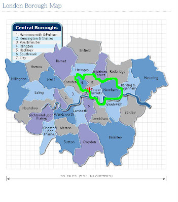
most tourist destinations are found in central
the rosetta stone and magna carta in southern camden; st. paul’s and the financial district in #7, the city of london; soho, the theater district, and the area generally termed as the ‘west end’ refer to westminister; notting hill/portabello market in kensington and chelsea (#2); and the globe theater and tate modern in southwark, along the thames.
compare those quintessential postcard images with the east end, home of a personal favorite, spitalfield’s. although its precise GPS coordinates shift each year, this locale generally includes the boroughs of tower hamlets and the southern part of hackney, both synonymous with poverty, overcrowding, disease and criminality (no worries, mom- guns are illegal.). X marks the spot where crisis, one of the organizations I’ll be working for, is located.
in december,
[for comparisons, sutton ranked 234; bromley, 228; and

blue represents the most deprived neighborhoods; white, desirable living areas.
these areas are dominated by rates of high unemployment and low education, both influenced by a large concentration of immigrants. the 2001 census for tower hamlets revealed that 58% of the population is from non-white british ethnic groups. a third is bangladeshi, half of whom are under 20 years old. 36% reported speaking a language other than english at home, 12% reported speaking no english. if all goes to plan, part of my serviceship will include ESOL classes.
